Location
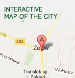
The Zelów Commune is located in the central- southern part of the Łódzkie Region. According to the administrative structure, it is situated in the north-western part of the Bełchatów District. The Dłutów Commune is its northern neighbour, the Drużbice and Bełchatów Communes border with Zelów in the East, Kluki and Szczerców in the South, and Widawa, Sędziejowice and Buczek in the West.
The Zelów Commune has a space of 16698.5 ha. It is one of the biggest communes in the Łódzkie Region and it covers 35 villages and 63 towns. 15427 persons live in the Zelów Commune, with a majority of 8161 living in the city.
The Zelów Commune is on the route of the inter-regional highway [No 44] leading via Łask - Piotrków Tryb. - Radom, the national highway [No 483] linking the cities of Łask - Szczerców - Częstochowa, and the national highway [No 484] leading via (Łask) - Buczek - Zelów - Bełchatów - Kamieńsk, which runs through the centre of the City of Zelów.
The Commune has a good communication network, with nearby cities in particular: Łódź (distance of 50 km), Łask (distance of 16 km) Bełchatów (distance of 16 km), and Warsaw (fairly convenient distance of 160 km). Public transport buses provided by the PKS (nationwide operator) ensure direct transport from Łódź to the centre of Zelów, and the MZK (local operator) travel between Bełchatów and Łask.
Back


